Wednesday morning, was the first day since we left PuntaTeonoste that we did not have a rigid agenda.
We took advantage of this and slept in a couple hours later than we had
any of the previous days. We had loose
plans of hiking in the cloud forest around the Selva Negra resort, possibly
going on a guided tour hosted by the resort, or perhaps exploring the city of
Matagalpa a bit.
We slowly got ourselves up and put together enough to go get
breakfast, a little bit tired from the non-stop running of the last several
days. We made the short walk over to the
restaurant, and picked out our usual morning booth and enjoyed some more coffee
and breakfast. Since Ryan has a strong
dislike for eggs (a fact of which his mother has been in an aggressive state of
denial for a few decades), he was left to order the one item on the menu that
didn’t come with eggs….pancakes and bacon….for the third day in a row. Nonetheless, they were just as good this day
as the last couple.
After a very leisurely breakfast, we realized it was after
10:00am and we should probably get up and find ourselves an adventure before
the day slips by. We went back to our
bungalow, washed up and got ready to go on a hike.
The lodge provided us a map, which illustrated 12 different
trails along and up the mountain side, ranging from 250 to 1600 meters long,
estimated hiking times of 10 to 90 minutes to complete. If the trails to the top of the mountain were
followed, they ascended 300 meters to an elevation of 1590m above sea level.
The trails were also rated as easy, medium, or difficult. We briefly discussed how much we’d hike, but
decided we’d simply play it by ear.


Ryan pulled out and put on his hiking gear. A lightweight loose fitting long sleeved
shirt, lightweight long pants, and his hiking boots. The clothing had been preemptively soaked in
permethrin to deter any mosquitos from sharing either Malaria or Zika (or any
other diseases for that matter) with
him. He was ready to go and grabbed a
backpack, throwing in some snacks, water, selfie stick…all the modern
necessities. When he turned around to
see how Aimee was doing, he saw that she was wearing a tank top, capris jeans
(with a bit of bedazzling on the pockets), and sandals.
 |
| Swollen Stream to Pond |
With a look of “meh”, Aimee replied, “These will be more
comfortable, and these sandals are hiking sandals.” She was right on the sandals. Ryan decided not to second guess, and pushed
the thoughts of a tarantula bite on the toe out of his mind as they headed back
towards the restaurant where the first of the paths began.
Ryan and Aimee made their way around the backside of the
pond, where the map indicated the Playitas trail
began. This narrow, but flat path followed around about a third of the pond. A few swollen streams led into the pond indicating that rain had been heavier than normal recently. Additionally, several spots of the path where very saturated. Nonetheless, the air was comfortably near 70, and the sky was beautifully partly cloudy and we made our way towards the point where the Playitas trail met up with the Cody trail.
began. This narrow, but flat path followed around about a third of the pond. A few swollen streams led into the pond indicating that rain had been heavier than normal recently. Additionally, several spots of the path where very saturated. Nonetheless, the air was comfortably near 70, and the sky was beautifully partly cloudy and we made our way towards the point where the Playitas trail met up with the Cody trail.
 |
| View of Restaurant from the Other Side of the Pond |
 When we reached the point where we expected to see a fork in
the trail, we found ourselves near the
When we reached the point where we expected to see a fork in
the trail, we found ourselves near the resort’s hostel style lodge. We paused, a bit perplexed as to where to go next. We didn’t see signage, and the map indicated the path went back behind the hostel. Clearly that was also the direction of the mountain. We saw a small gravel path that looked like it led to the entry of the hostel. We didn’t figure this could be the path as it seemed intrusively close to the hostel itself. Nonetheless we followed it, and sure enough it continued behind the building and led into the forest.
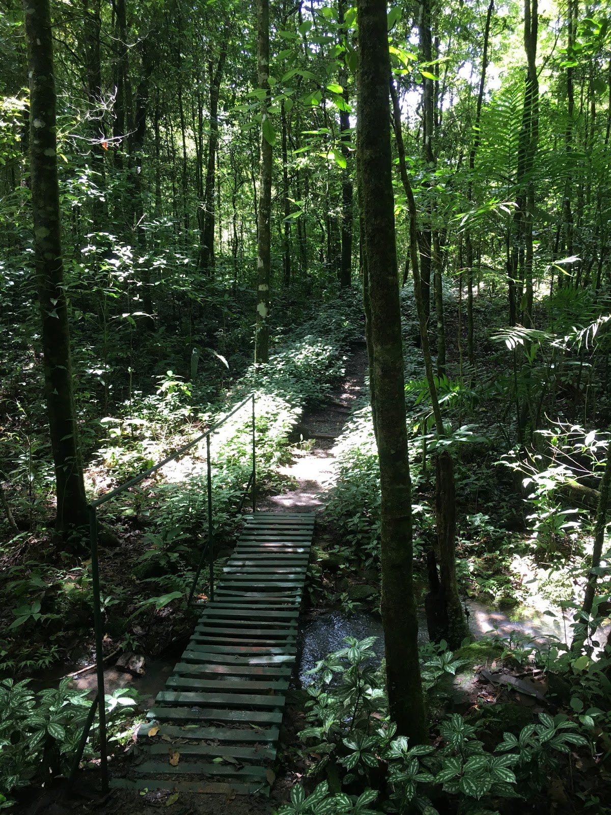 The path was narrow, only about 18 inches wide or so on
average, with small bridges, and sets of steps here
The path was narrow, only about 18 inches wide or so on
average, with small bridges, and sets of steps hereand there, and an occasional bench to sit and watch the scenery. Periodically we’d cross over small streams of water cascading down from higher up the mountain. Our map showed us that we’d soon be meeting up with the Pilas trail. As we got closer, the origin of the trails name was clear. Here, where Pilas met Cody, were several large tanks collecting water from the streams, with pipe’s leading down towards the resort. Quite likely, this was where our showers were fed from.
We decided to skip this trail for now, as further ahead on
the Cody trail, was the area of the jungle that the howler monkeys were known
to frequent. We kept our eyes up in the
trees, looking for the howler monkeys, or sloths, (which we still had not come
across yet) or of course more capybara of which Aimee had not yet had her fill.

A bit further, our trail met up with the Atajo trail, which
would take us a little further up the mountain, and
keep us in the area of the monkeys. We had yet to see any so we decided to go this way, hoping to
 improve our chances. Our map labeled this as a “medium” difficulty
trail. While there was nothing
exceptionally challenging about it, it was much more overgrown, and
uneven. Periodically however we did
still see benches, and signs of civilization along the path. At one point the path got more difficult to
see, and we were not sure which direction we should be going. It appeared either the path went off to the
right, or straight ahead. Both kind of
looked like they were just leading us into the jungle.
improve our chances. Our map labeled this as a “medium” difficulty
trail. While there was nothing
exceptionally challenging about it, it was much more overgrown, and
uneven. Periodically however we did
still see benches, and signs of civilization along the path. At one point the path got more difficult to
see, and we were not sure which direction we should be going. It appeared either the path went off to the
right, or straight ahead. Both kind of
looked like they were just leading us into the jungle.
keep us in the area of the monkeys. We had yet to see any so we decided to go this way, hoping to


We decided the one ahead looked like more of a path, and
began to follow it. A few minutes later,
we decided it probably wasn’t the right choice.
While it seemed likely that we weren’t the first ones to head this
direction, it seemed noticeably less clear than the path we had been on. We continued on for a bit, figuring from the
map that even if we weren’t on the path we thought we were, that it would meet
up with the Romantico path soon. Sure
enough, after 10 minutes or so, we came out on a broader path, and saw a sign
that labeled it as Romantico. A quick
exploration of the trail made it clear that we had indeed carved our own shortcut
between Romantico and Atajo, when we found indicating the official junction
with the end of the Atajo trail was several meters further down.


After scoping out the area, we followed this also very
narrow (but clearly more travelled) path to the left, pondering the origin of
the name of this path. It was very
isolated, and we hadn’t seen or heard anyone since we began our hike 45 minutes
earlier. It was very scenic, but no more romantic than any of the other trails.
 While we continued debating what made it so romantic, we
came upon a small sign that indicated we were at the “Peter and Helen”
trail. Ryan pointed out that this was
one of the “difficult” rated trails.
Aimee shrugged, and set let’s give it a try.
While we continued debating what made it so romantic, we
came upon a small sign that indicated we were at the “Peter and Helen”
trail. Ryan pointed out that this was
one of the “difficult” rated trails.
Aimee shrugged, and set let’s give it a try. When planning the trip, Ryan had come across the history of
this trail, though aside from remembering that he had read the story, he
couldn’t remember the details. It turns
out that shortly after this trail had been marked (but before it was named), a
middle aged couple named Peter and Helen had left the Selva Negra lodge and
mentioned they were going to go explore the trail. As dusk set in, employees at the lodge
realized they never saw the couple return.
Concerned, they sent out a group to find them. Sure enough they found them up the
mountainside, lost in the now dark jungle.
They escorted them back to the lodge.
The workers ultimately decided that given their adventure on the trail,
that it should be named after Peter and Helen.
(Although it’s not known if the namesakes ever learned that the trail
was named in their honor)
When planning the trip, Ryan had come across the history of
this trail, though aside from remembering that he had read the story, he
couldn’t remember the details. It turns
out that shortly after this trail had been marked (but before it was named), a
middle aged couple named Peter and Helen had left the Selva Negra lodge and
mentioned they were going to go explore the trail. As dusk set in, employees at the lodge
realized they never saw the couple return.
Concerned, they sent out a group to find them. Sure enough they found them up the
mountainside, lost in the now dark jungle.
They escorted them back to the lodge.
The workers ultimately decided that given their adventure on the trail,
that it should be named after Peter and Helen.
(Although it’s not known if the namesakes ever learned that the trail
was named in their honor)
The beginning of the trail did not look to difficult, though
it did head more directly up the mountain and was a
much steeper path. At one point, a series of “steps” had been
created by a few dozen old tires that were set into the side of the mountain,
allowing for a stable climb. After about
20 minutes of faint trails meandering back and forth but ever upward, we
noticed that the trail began to more consistently zig zag up the side of the
mountain every 50 to 100 feet or so.
This side of the mountain was generally around a 45-degree angle, and
the path was now an 18 to 24 inch “ledge” of fairly soft dirt. Every time we turned on onto one of the zigs
or zags, we looked up the mountain thinking it couldn’t be that much further to
get to the top of it. However, the dense
jungle, made it very difficult to gauge anything. We continued what was becoming a tedious back
and forth hike up and up and up, as we felt our legs starting to burn from the
constant slow ascent. The sky began to
darken a little bit as some heavier clouds rolled in, and a couple times a
faint drizzle wafted down through the trees.
 |
| Tire Stairs |

 |
| Are we almost there yet? |
The section of missing path was small enough to take a wide
step, or small jump over, except that there was
a tree and shrubs in the way. The foliage on its own would have been easy enough to work our way around---but the path was missing underneath. The two obstacles together made this a much more formidable barrier to our progress.
a tree and shrubs in the way. The foliage on its own would have been easy enough to work our way around---but the path was missing underneath. The two obstacles together made this a much more formidable barrier to our progress.
 |
| Zigging... |
Ignoring Aimee’s half-hearted protests, Ryan pulled away
some of the loose foliage, found a hand hold, and swung himself over the gap
while half-hugging the botanical barrier blocking what used to be the
path.
He turned and offered a proud smile and held out a hand for
Aimee, who shook her head and hesitantly
moved forward, refusing the hand, but
managing to cross the gap without too much difficulty. At this point it seemed we had to be close to
the top. We zig zagged up a few more
times, and it even seemed like the forest was lightening up a bit, however we
continued to zig….and zag….and zig….and zag.
Several times we questioned whether we were still on the trail, when it
wasn’t clear if we should be zigging or should be continuing to zag. However, we noticed that there were periodic
machete marks on the trees to mark the
trail. At one point we stopped to rest, and look at the view of the cloud forest below us.
 |
| ...and Zagging up Peter and Helen |
trail. At one point we stopped to rest, and look at the view of the cloud forest below us.

After another 15 minutes or so, we finally came to what
appeared to be the end of the Peter and Helen trail. Sure enough, there was a small sign that said
“Fin de sendero” and another sign that had the name of the trail that traversed
the crest of the mountain: “Mosquitia”. This was also listed as a “difficult” trail
on our map. But we figured, it had to be
a bit easier than what we just hiked for the last 60 to 90 minutes. Additionally, we were only going to hike about
a quarter of the full Mosquitia trail in order to get to the Fuente Joventud
(Fountain of Youth) trail which would take us down the mountain.

We soon realized that this trail was definitely not any
easier. While we were at the top of the
mountain and
no longer ascending continually, we realized the top of the
mountain was not level. The trail
ascended then descended multiple large, steep hills of about 10 meters, and
then would descend steeply with very uneven terrain some of which was soft
soil, some was hardpacked with rocks, and some was squishy mud. To make it fun, the different types of trail
quality often looked the same or similar.
Aimee was enjoying the hike less and less. After each hill, Ryan said optimistically, it
must flatten out ahead, or the next hill looks less steep…only to find as we
got closer to it that it was just as treacherous as the last one.
 |
| Mosquitia |
It only took another 20 minutes or so to get to the Fuente
Joventud trail head, and we were excited about heading back towards the resort
as opposed to moving away from it…and down is always easier than up,
right?
 |
| Matagalpa in the Distance |
It was getting close to 3:00pm at this point, and we did
notice that the light was starting to change, and we
realized it would get darker quicker in the jungle that it did in open land. At this time of year in Nicaragua sunset was around 6:30pm, so we weren’t sure at what point we’d begin to have a hard time seeing up here, but we knew we didn’t want to find out. We tried to keep a steady pace, but to avoid injury, we had to be fairly measured and calculating in our decent.
realized it would get darker quicker in the jungle that it did in open land. At this time of year in Nicaragua sunset was around 6:30pm, so we weren’t sure at what point we’d begin to have a hard time seeing up here, but we knew we didn’t want to find out. We tried to keep a steady pace, but to avoid injury, we had to be fairly measured and calculating in our decent.
 It was clear that Aimee and Ryan had two very different
approaches. When possible, Ryan would
look for
It was clear that Aimee and Ryan had two very different
approaches. When possible, Ryan would
look for a landing point within 15 feet or so and that would provide some margin for error. He would then scope out a few places to use as steps that seemed halfway solid, and as long as the way was fairly unobstructed, he would then attempt to descend using a controlled fall, slowing his descent by stepping briefly, gently, and swiftly on each potential foot hold, and ultimately landing on the next platform lower.
Aimee took a much more measured approach and would attempt
to crab walk (to the great unease of Ryan, who was sure that this would end in
a dislocated shoulder should she loose her footing) down the trail.
On the more vertical sections of trail, Ryan would attempt
to climb down as if on a ladder, though some of these sections provided very
few hand and foot holds. Aimee continued
the approach of attempting to descend on her
butt, as Ryan looked on nervously trying
to encourage her to climb down facing the mountain side. After each segment, she would stop to vent
her frustrations by cursing at the trail.
Meanwhile, Ryan did quietly thank God that it didn’t start raining while
they were out there. This trail would
have been extremely difficult in rain.
The only strategy he could even imagine for rainy conditions would be to
slide down these sections like a water slide.
 |
| Aimee is Tired of Fuente Joventud |
After what seemed like an endless series of near vertical
descents for about 45 minutes, Aimee’s backside was now completely covered in
mud. The angle of the path was not quite
as treacherous, but still descended at a very quick rate. Aimee suddenly decided she was in absolute
need of a walking stick to finish the climb down. She looked in earnest as we continued to
descend, finally finding one that she felt was suitable. She now used this to help her keep her
balance on the uneven ground.
Several times, Ryan who was usually ahead of her, would turn
around in amusement. Aimee in her hiking
sandals, tank top, and walking stick, with dirt all over her, looked a bit like
a strange jungle warrior (albeit a very pale one).
 |
| Jungle Warrior Aimee |
Eventually, the path began to level out a bit, and we
ultimately met back up with the Romantico path, a little further down from
where we had left the path a few hours earlier.
From here on out, we only had “medium” and “easy” trails to hike. It was almost 4, and the jungle was quite a
bit darker than it was on hour ago. We
walked at a swift pace again crisscrossing on rudimentary bridges over streams
coming down the mountainside. Finally, at about 4:30, almost 6 hours after
we entered the hiking trails, we came back around the lake and past the
restaurant.
Without any discussion necessary, Aimee and Ryan agreed that
after washing up, the evening would be spent eating dinner, and relaxing in the
restaurant with a few drinks.


Ryan reminded Aimee that the map called some of them ‘difficult.’ “Yeah, but we’re at a resort! When I think of
resort, I think of 70 year olds going out for a walk. I figured it would be ‘difficult’ for someone
that age, not mine!” Aimee replied.
After enjoying dinner and many beverages in the restaurant,
we returned back to our room, and decided to turn in early in order to rest up
for the long drive ahead of us to Grenada.
 |
| Dinner Time View |
 |
| Moth With 5" Wing Span at Restaurant on Light |
No comments:
Post a Comment